Caribbean Earthquake and Volcano Activity
Things you need to know about cruise ship safety before you leave port

Venice
Get to know our slice of Paradise - located on the SW Coast of Fl.
Attractions
Beaches
Canoe/Kayak
Boat Launches
Boat Charters
Fishing Charter
Fishing Piers
Historical Sites
Golf
Parks
Hotels
Relocate
Venice Map
advice > safety > natural hazards -Caribbean
Cruise Ship Natural Hazards
Know before you go!
A natural hazard is a threat of a naturally occurring event that will have a negative effect on people or the environment. Many natural hazards are interrelated, e.g. earthquakes can cause tsunamis.
Tsunami Warning Links
Pacific Tsunami Warning Center West Coast & Alaska Tsunami Warning Center
Caribbean Tsunami Warning Program Puerto Rico Seismic Network
Caribbean Seismic Activity
The islands of the Caribbean are located in a region southeast of the Gulf of Mexico and Northern America, east of Central America, and to the north of South America.
Source: USGS
Caribbean Tectonic Plate
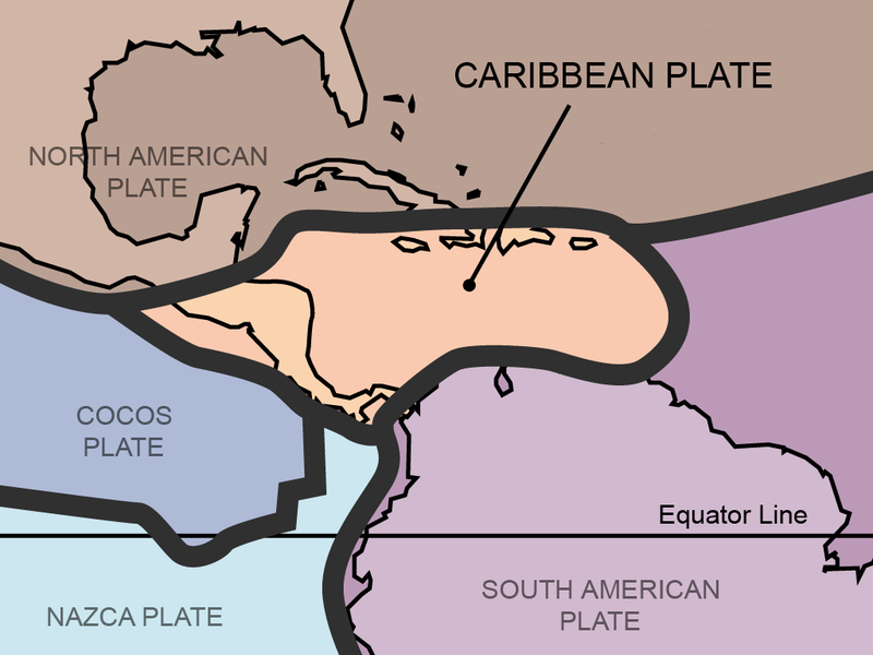
The Caribbean Plate is a mostly oceanic tectonic plate underlying Central America and the Caribbean Sea off the north coast of South America. Diversity of tectonic regimes characterizes the perimeter of the Caribbean plate, involving no fewer than four major adjacent plates (North America, South America, Nazca, and Cocos).
Caribbean Plate Seismic Activity

The Puerto Rico Trench, which is capable of producing earthquakes of magnitude 7 to 8 or greater, faces north and east into the Atlantic Ocean. There are few land areas or islands to block a tsunami generated near the Puerto Rico Trench from entering the Atlantic Ocean. The direction of the waves would depend on many factors, including where in the trench the earthquake occurred.
Mexico Seismic Activity
Mexico Tectonic Plates

Situated atop three of the large tectonic plates that constitute the Earth's surface, Mexico is one of the most seismically active regions on earth. The motion of these plates causes earthquakes and volcanic activity.
Mexico Earthquake Density

Areas of Mexico's coastline on the Gulf of California, including the Baja California Peninsula, are riding northwestward on the Pacific plate. Rather than one plate sub ducting, the Pacific and North American plates grind past each other, creating a slip fault that is the southern extension of the San Andreas fault in California.
Mexico Seismicity

Motion along this fault in the past pulled Baja California away from the coast, creating the Gulf of California. Continued motion along this fault is the source of earthquakes in western Mexico.
Eastern Caribbean Volcanoes

Active Volcanoes in the eastern Caribbean include:
Kick-em'-Jenny near Grenadines: most recent eruption was 2001;
Soufrière Volcano, Guadeloupe: most recent eruption was 1977;
Mont Pelée, Martinique: most recent eruptions 1929 to 1932; Soufrière Hills, Montserrat: most recent eruption 2010; La Soufrière, St. Vincent: most recent eruption was 1979.
Maps
USGS Tectonic Plates Map

Earthquake epicenters 1963-1998

The Soufriere Hills Volcano
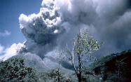
The island of Montserrat has a very active volcano and the Government of Montserrat has issued several recent proclamations and warnings urging residents and visitors to be vigilant and to be prepared to move at short notice.
Ongoing volcanic activity in the south of the island has led to the evacuation and relocation of residents of the so called ‘exclusion zone' since 1995. Additional evacuations may occur when volcanic activity increases. Because the volcano is still active and dangerous, access to the southern part of the island is restricted. Persons entering restricted areas without authorization are subject to fine and/or imprisonment. In early 2007, Montserrat government authorities warned residents and visitors of volcanic activity and an increase of pyroclastic flows in Tyres Ghaut, Gages Valley and behind Gages Mountain. After placing sections of the lower Belham Valley off limits in January 2007 due to the danger posed by growth of the volcano’s dome, the government of Montserrat lifted those restrictions in September. Access to all areas on the southern flanks of the Belham Valley east of the Belham Bridge and areas south remains prohibited, as is south of Jack Boy Hill to Bramble Airport and beyond.
Good to Know
Early warning systems pose a problem in the Caribbean
The Caribbean Tsunami Warning Program (CTWP) was established in 2010 as the first step of a phased approach for the establishment of a Caribbean Tsunami Warning Center (CTWC). As funding permits, its staff will continue to grow over the years to meet the requirements of a CTWC.
About Earthquakes
An earthquake (also known as a tremor or temblor) is the result of a sudden release of energy in the Earth's crust that creates seismic waves. Earthquakes are recorded with a seismometer, also known as a seismograph. The moment magnitude (or the related and mostly obsolete Richter magnitude) of an earthquake is conventionally reported, with magnitude 3 or lower earthquakes being mostly imperceptible and magnitude 7 causing serious damage over large areas. Ordinarily, subduction earthquakes under magnitude 7.5 on the Richter scale do not cause tsunamis, although some instances of this have been recorded. Most destructive tsunamis are caused by earthquakes of magnitude 7.5 or more.
About Tsunamis
Anything that rapidly displaces a large volume of water can cause a tsunami. Typically, tsunamis are caused by underwater earthquakes, but landslides, volcanic eruptions, calving icebergs, and (very rarely) meteorite impacts can also generate tsunamis. These types of events can cause large disturbances in the surface of the ocean, and when gravity pulls the water back down, the tsunami is born. The original Japanese term literally translates as "harbor wave."
International Tsunami Information Center (ITIC) - ITIC coordinates the efforts to extend the services of the national tsunami warning system of the United States to the international community in the Pacific basin.
Related Links:
Weather UpdatesTravel Warnings
Safety Overview
Cruise Ship Fires
Sunken Passenger Ships
Sudden Lists/Rogue Waves
Unclassified Incidents
Coronavirus
Norovirus
Incidents 2012
Incidents 2013
Incidents 2014
Incidents 2015
Caribbean and Mexico Port Calls
Eastern CaribbeanAnguilla |
Western CaribbeanBelize |
Southern CaribbeanAruba |
Mexican RivieraAcapulco Yucatan PeninsulaCozumelCosta Maya Progreso/Merida |