Santo Tomas de Castilla Cruise Port
Cruise Ship Port of Call information like Port News, Weather, Transportation Options, Things to Do and See, Area Events, Medical Care, Crime and Safety Review


Venice
Get to know our slice of Paradise - located on the SW Coast of Fl.
Attractions
Beaches
Canoe/Kayak
Boat Launches
Boat Charters
Fishing Charter
Fishing Piers
Historical Sites
Golf
Parks
Hotels
Relocate
Venice Map
Western Caribbean Port Calls
Belize
Cozumel
Costa Maya
Falmouth
Grand Cayman
Mexico
Montego Bay
Ocho Rios
Playa del Carmen
Progreso/Merida
Roatan
Roseau
San Tomas
Santo Tomas de Castilla Area Weather
Need to know
Medical Services
A full range of medical care is available in Guatemala City, but medical care outside the city is limited.
Guatemala's public hospitals frequently experience serious shortages of basic medicines and equipment. Care in private hospitals is generally adequate for most common illnesses and injuries, and many of the medical specialists working in them are U.S. trained and certified.
Getting around
Services at this port are limited and driving is treacherous so check with your cruise company to explore what excursions are offered.
Common public transportation is by local recycled school busses, which serve every town in the country. Criminal activity and frequent fatal accidents, however, make the low-priced inter-city buses particularly dangerous. Modern inter-city buses offer some security from highway violence, but armed attacks are increasing, showing that all buses are vulnerable.
Driving
Traffic rules are only casually observed. Many drivers do not use their turn signals to alert other drivers. Instead, a common custom is for a driver or passenger to stick a hand out the window and wave it to indicate that they will be taking an unspecified action.
Speed limits, lane markings and stop signs are frequently ignored.
Passing blindly on winding and/or steep mountain roads, poorly designed surfaces, and unmarked hazards, including frequent landslides and precarious temporary highway repairs, present additional risks to motorists.
Although city streets are lit, secondary and rural roads have little to no illumination.
Driving outside of urban areas at night is dangerous and not recommended.
Valid U.S. driver's licenses are accepted for the first 30 days of a visit, and international driving permits are accepted in Guatemala for extended stays.
Drivers use the right-hand side of the road in Guatemala. Speed limits are posted in kilometers.
Turning right on red is not permitted unless otherwise posted, and drivers must yield when entering a traffic circle.
Seat belts must be worn in Guatemala, but there are no laws regarding the use of child safety seats. It is against the law for drivers to operate cellular phones while driving.
In an accident resulting in injury or death, every driver involved is taken into custody and the vehicle(s) impounded until a judge determines responsibility in a re-enactment of the accident.
ports > destinations > Santo Tomas de Castilla
Santo Tomas de Castilla
Santo Tomas de Castilla is a modern port located just to the southwest of Puerto Barrios. Puerto Barrios is a port city in Guatemala located within the Gulf of Honduras - just south of Belize in the Bay of Amatique. See Map Below.
In 2004, Santo Tomás de Castilla started receiving cruise ships. The cruise ship terminal is a tremendous boost for the Guatemalan tourism industry. Currently, four cruise companies include Santo Tomas de Castilla in their schedule including Regent Seven Seas Cruises, Oceania Cruises, Silversea Cruise Line and Holland America Line. Cruise ship passengers visit Guatemala mostly for its Maya culture, spread throughout the country.
An earthquake on February 4, 1976, destroyed most of the port facilities of Puerto Barrios and most modern cargo traffic moved to its twin port in Santo Tomás de Castilla (administratively a part of Puerto Barrios). Today, Puerto Barrios remains an important hub for Dole and Del Monte industries.
Guatemala has a developing economy, characterized by wide income disparities. Hotels and other tourist facilities in the principal tourist sites most frequented by visitors from the United States are generally good to excellent.
Violent crime is a serious concern due to endemic poverty, an abundance of weapons, a legacy of societal violence, and dysfunctional law enforcement and judicial systems.
Good to Know
Port of Entry
Santo Tomás de Castilla, also known as Matías de
Gálvez It lies at Amatique Bay off the Gulf of Honduras and is
administratively a part of Puerto Barrios.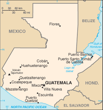
Time Zone
CST (EST-1, UTC,GMT - 6)
Map Coordinates
15.°41′N, 88.°36′W
Average Temperatures
Water: 82º Summer - 78º Winter
Air: 85º Summer - 79º Winter
Personal Safety
Incidents include, but are not limited to, assault, theft, armed robbery, carjacking, rape, kidnapping, and murder. Most tourists and visitors travel throughout Guatemala without mishap. However, violent criminal activity on the highways continues, and tourists, among others, have been targeted. Many of the robbery attempts have occurred in daylight hours on main highways. Carjacking incidents and highway robberies are often violent.
A popular scam involves various attempts to acquire a victim’s ATM card and PIN number. Some sophisticated criminals have even placed boxes outside ATM kiosks that record PIN numbers when unsuspecting victims believe they must enter their PIN number to gain entry to the ATM foyer. After recording PIN numbers, robbers then steal the owner’s ATM card to complete their crime.
There are dozens of techniques scammers can use to rob victims of money and possessions. While most people mean no harm, always be cautious when strangers approach you for any reason or make unusual requests.
POLITUR (a joint police/Guatemalan Tourism Institute initiative) is present in all major tourist destinations. They should be contacted in case of any criminal incident in such areas, even if minor.
Things to do and see
Main Street
A Naval Base and the Belgian Cemetery can be located on the main streets of Santo Tomas de Castilla.
El Castillo de San Felipe
An old Spanish fort guarding the entrance to the Izabal Lake.
Lake Izabal
Guatemala's largest lake, more than 27 miles long and covering about 366 square miles. Most tours of Lake Izabal begin in the town of Frontera, where a bridge spans the Rìo Dulce , which drains the lake. The Castillo de San Felipe is found about a half mile from the bridge.
Quirigua National Park
The Mayan ruins of Quirigua.
Livingston Town
Experience Garifuna culture here.
Rio Dulce
Jungle river inhabited by the Maya-Q'eqchi' ethnic group. The river runs about 25 miles from Lake Izabal before it empties into Amatique Bay at Livingston
Rio Dulce National Park
Ecological preserve.
Beaches
Beware of strong currents, riptides, and undertow along Guatemala's Pacific Coast beaches. They pose a serious threat to even the strongest swimmers. Signs warning of treacherous surf are rare and confined mostly to private beaches owned by hotels. Lifeguards are rarely present on beaches.
Back to the top