Antigua Cruise Ship Destination Port
Cruise Ship Port of Call information like Port News, Weather, Transportation Options, Things to Do and See, Area Events, Medical Care, Crime and Safety Review
Venice
Get to know our slice of Paradise - located on the SW Coast of Fl.
Attractions
Beaches
Canoe/Kayak
Boat Launches
Boat Charters
Fishing Charter
Fishing Piers
Historical Sites
Golf
Parks
Hotels
Relocate
Venice Map
More Port Calls
Bahamas
Castaway Cay
Freeport
Coco Cay
Half Moon Cay
Nassau
Princess Cay
Stirrup Cay
Eastern Caribbean
Anguilla
Antigua
Casa de Campo
Catalina Island
Grand Turk
Labadee
La Romana
Samana
San Juan
St. John
St. Croix
St. Thomas
St. Maarten/Dutch
St. Martin/French
Tortola
Antigua Weather
Need to know
Hurricanes
Anguilla is situated in an area prone to hurricanes. From June to November, the country may experience strong winds and rains as a result of hurricanes in the Atlantic.
In the event of a tropical storm or hurricane, go to our Tropical Storm Update page
Government
The islands became an independent state within the British Commonwealth of Nations in 1981.
Crime
The Government of Antigua and Barbuda has taken steps to improve the effectiveness of the police in responding to crimes. As everywhere, visitors to Antigua and Barbuda are advised to be alert and maintain the same level of personal security used when visiting major U.S. cities.
Medical Facilities
There are many qualified doctors in Antigua and Barbuda, but medical facilities are limited to a public hospital and a private clinic and are not up to U.S. standards. There is no hyperbaric chamber; divers requiring treatment for decompression illness must be evacuated from the island, to either Saba or Guadeloupe.
Getting around
Driving
Traffic in Antigua and Barbuda moves on the left. Major roads are generally in good condition, but drivers may encounter wandering animals and slow moving heavy equipment. There is relatively little police enforcement of traffic regulations. Buses and vans are frequently crowded and may travel at excessive speeds. Automobiles may lack working safety and signaling devices, such as brake lights.
The Barbuda Express
High speed ferry with a journey time of 90 minutes in nearly all weather conditions. It runs 5 days a week between St Johns and Barbuda.
Taxis
Fares between the airport, harbor, and many hotels and destinations are fixed and can be obtained upon arrival. Taxi drivers are also qualified as tour guides for sightseeing trips.
ports > destinations > Antigua
Antigua

|
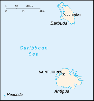
Located in the middle of the Leeward Islands in the Eastern Caribbean, roughly 17 degrees north of the equator. Barbuda, a flat coral island with an area of only 68 square miles, lies approximately 30 miles due north.

The largest of the English-speaking Leeward Islands, Antigua is about 14 miles long and 11 miles wide, encompassing 108 square miles. Mostly low lying with some volcanic areas. Barbuda is without streams or lakes and receives less rainfall than Antigua. Boggy Peak 1,319 ft (402 m) is the highest point located in the southwestern corner of the island.
Good to Know
Antigua and Barbuda is a dual island nation in the Eastern Caribbean and is best known as the country with 365 beaches (one for each day of the year). To the north and west are Nevis, St. Kitts, St. Barts, and St. Martin, and to the south are the islands of Montserrat and Guadeloupe.
The high rocky coast of Antigua is indented by many bays and arms of the sea, several of which form excellent harbors. The surface is comparatively flat, and there is no central range of mountains as in most other Caribbean islands, but among the hills in the southwest an elevation of 1,319 feet (402 m) feet is attained on Boggy Peak.
Barbuda, located north of Antigua, was leased to the Codrington brothers in 1685. The Codrington family produced food on their land in Barbuda, and also transported slaves as labor for their sugar plantations on Antigua. There was more than one slave rebellion at Codrington during the 1740s, during which slaves rose against managers. All the slaves were freed in 1834.
Good to Know
Port of Entry
St. John's - Heritage Quay or Nevis Pier.
Time Zone
AST (UTC/GMT - 5)
Map Coordinates
17.03 N, 61.48 W
Average Temperatures
Water: 82° Summer - 77° Winter
Air: 82° Summer - 78°Winter
Ships Calling
Serenade of the Seas (2012) and Jewel of the Seas (2013 & 2014), Emerald Princess, Carnival Breeze.
Things to do and see
Nelson's Dockyard
(the only remaining Georgian Naval Dockyard)
Located at English Harbor on the
southeastern coast. Famed for its protected shelter during violent storms
and is the site of "Nelson's Dockyard" after Captain Horatio Nelson. Today
English Harbor and the neighboring village of Falmouth are internationally
famous as a yachting and sailing destination and provisioning center.
Dockyard buildings have been converted into restaurants, museum, a bakery
and shops.
Shirley Heights
From the Heights one can look far out over English Harbor, and on Sunday afternoons the view is accompanied by barbecue, rum punch, and the plangent strains of steel band and reggae music.
Museum of Antigua & Barbuda, St John's
Not just regaling visitors with Antigua's recent, colonial and post-colonial past, but including fossil and coral exhibits some 34 million years old, the Museum of Antigua & Barbuda is a must.
Sea View Farm Village
The clay is collected from pits located nearby, and the wares are fired in an open fire under layers of green grass in the yards of the potters' houses. Buyers should be aware that Antiguan folk pottery breaks rather easily in cold environments.
Harmony Hall
Brown's Bay at Nonsuch Bay, is the center of the Antiguan arts community. Exhibits change throughout the year, but the annual highlights are the Antigua Artist's Exhibition and the Craft Fair, both in November. The sugar mill tower around which Harmony Hall is built has been converted to a bar and provides its patrons with one of the island's best panoramic views.
St. John's Cathedral
Built in 1845.
The Coast Bar & Restaurant in St. John's
At Heritage Quay recommended on Antigua message boards. Offers informative website and on-line menu. Website
Betty's Hope, Pares
For a taste of the colonial Caribbean, visit Betty's Hope on Antigua, a restored sugar cane plantation.
Frigate Bird Sanctuary, Codrington Village
Salty lagoon on the north-west corner of the island of Barbuda lies an enormous rookery inhabited by one of the most fascinating bird species anywhere, the Frigate Bird, regata magnificens. A 40 minute boat ride from Antigua.
Highland House
18th century home of the Codrington family.
Indian Cave
Contains ancient Amerindian petroglyphs (rock engravings).
Beaches
Dickenson Bay
There are wilder, more deserted beaches to the south of the island, but
head to Antigua's Dickenson Bay for fully-equipped fun for all the family,
and stretches of gorgeous white sand.
● Diamond Reef
● Boon Reef
● Sandy Island
● Cades Reef
Carlisle Bay
South coast
Crab Hill and Darkwood Beach
Southwest coast.
Fryes Beach
Located at Fryes point on the west coast.
Galley Bay Beach
Located at 5 Islands Village on the northwest coast.
Jabberwock Beach
Located on the north .coast
Half-Moon Beach
About a five minute drive from Freetown Village on the southeast coast.
Pigeon's Point Beach
About a 5 mile drive from English Harbor on the southeast coast
Jolly Beach
At Long Bay on the east coast
Wapping Beach
Located in the heart of St. John's.


