San Juan, PR Cruise Ship Destination Port
Cruise Ship Port of Call information like Port News, Weather, Transportation Options, Things to Do and See, Area Events, Medical Care, Crime and Safety Review

Venice
Get to know our slice of Paradise - located on the SW Coast of Fl.
Attractions
Beaches
Canoe/Kayak
Boat Launches
Boat Charters
Fishing Charter
Fishing Piers
Historical Sites
Golf
Parks
Hotels
Relocate
Venice Map
Eastern Caribbean Port Calls
Bahamas
Castaway CayFreeport
Coco Cay
Half Moon Cay
Nassau
Princess Cay
Stirrup Cay
Eastern Caribbean
AnguillaAntigua
Casa de Campo
Catalina Island
Grand Turk
Labadee
La Romana
Samana
San Juan
St. John
St. Croix
St. Thomas
St. Maarten/Dutch
St. Martin/French
Tortola
San Juan Weather
Need to know
Medical Services
San Juan has an elaborate system of both public and private triage, hospital, and preventive care health services.
There are 20 hospitals in San Juan, half of them operated by the government.
The main government hospitals are:
Centro Medico (General Hospital)
This is the main hospital for trauma cases cases in Puerto Rico and the Caribbean.
Administración de Servicios Médicos de Puerto Rico - ASEM
Centro Médico de Puerto Rico
Barrio Monacillos
San Juan, PR 00935-0001
Phone: (787) 777-3535
Caribbean Pediatric and Surgery Hospital
371 Avenida De Diego, San Juan, PR 00923 Website: http://sanpablo.com Telephone: 787-767-2528
Centro Cardiovascular del Caribe (Cardiovascular Center)
This is the main hospital for open heart surgery in the Caribbean. It features a hotel for the patients families.
Americo Miranda Centro Medico, San Juan, PR 00936
(787) 754-8500.
Getting around San Juan
A walking tour is great way to see the Old City.
If you need a break, hop aboard the no-charge trolley cars! They make rounds to and from La Puntilla and Covadonga parking lots at clearly marked stops.
Affordable Buses
There are public buses in San Juan (they call them guaguas) that cover all the tourist zones. For example, the A-5 bus will take you from Isla Verde Avenue to Old San Juan in about 45 minutes to an hour, depending on stops and traffic.
Area Events
San Sebastiàn Street Festival
January annual event in Old San Juan Carnival atmosphere with live music, fair ride and food vendors.
Coffee Harvest Festival
Annual February event
Heineken Jazzfest
May Annual Event at the Tito Puente
Amphitheater
Brings together some of the biggest names in Latin Jazz.
Website
ports > destinations > San Juan
San Juan, Puerto Rico
Puerto Rico is located between the Caribbean Sea and the North Atlantic Ocean. San Juan is located along the north-eastern coast of Puerto Rico and lies south of the Atlantic Ocean.

During the early 16th century, San Juan was the point of departure of Spanish expeditions to charter or settle unknown parts of the New World. Its fortifications repulsed the English navigator Sir Francis Drake in 1595, as well as later attacks.
Puerto Ricans were granted US citizenship in 1917. Popularly-elected governors have served since 1948. In 1952, a constitution was enacted providing for internal self government. In plebiscites held in 1967, 1993, and 1998, voters chose not to alter the existing political status.
San Juan is the largest processing center of the island and the port is one of the busiest in the Caribbean. San Juan is the country's financial capital, and many U.S. banks and corporations maintain offices or distributing centers there. San Juan is the center of Caribbean shipping and is the 2nd largest sea port in the area (after New York City).
Old San Juan occupies the western end of a rocky islet at the mouth of San Juan Bay. During the 20th century, the main population centers surged well beyond the walls of the old city and onto Puerto Rico's main island, and merged with the existing settlements east and south of Old San Juan. As a result, the city is now composed of a variety of neighborhoods.
Natural Hazards
Puerto Rico is subject to natural hazards that include hurricanes, tsunamis & earthquakes and mud slides.
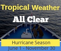
Hurricanes
Puerto Rico is situated in an area of the Caribbean prone to hurricanes. Periodic hurricanes occur between June and November. In the event of a tropical storm or hurricane alert, a notice will be posted on our Weather page.

CAT 1 hurricanes near or over Puerto Rico 1851 - 2004
Earthquakes and Tsunamis
Puerto Rico lies at the boundary between the Caribbean and North American plates and is being deformed by the tectonic stresses caused by their interaction. These stresses may cause earthquakes and tsunamis. The most recent major earthquake occurred on October 11, 1918, and had an estimated magnitude of 7.5. The epicenter of the Earthquake was located in the Mona Passage about 9.9 mi from the northwestern coast of the island. The Earthquake triggered a Tsunami with waves measured at approximately 20 feet. The losses resulting from the disaster were approximately 116 casualties and $4 million in property.
|
Earthquake warnings can be viewed at the USGS website Tsunami warnings can be viewed at the Puerto Rico NWS website |
 San Juan Tsunami Flood Study Map (USGS) |
Good to Know
Port of Entry
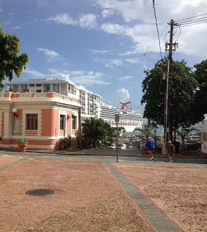
Cruise ships arrive at one of the eight piers located on the northern and eastern side of the bay; located south of Old San Juan and the San Juan island. The short distance between the Airport and the cruise ship docks (7 miles) makes the docks a prime location for cruise companies.
Time Zone
AST (UTC/GMT -4 )
Climate
The climate is subtropical and mild with little seasonal temperature variation. The terrain is mostly mountains with a coastal plain belt in the North region.
Area
The city of San Juan occupies an area of 76.93 square miles of which, 29.11 square miles is water. The population estimate in 2006 is 450,000.
Map Coordinates
18.15 N, 66.30 W
Average Temperatures
Water: 82º Summer - 78º Winter
Air: 85º Summer - 79º Winter
Things to do and see
Shopping
Business hours usually are, 6:00 AM to 6:00 PM weekdays. Most stores are open Saturdays, and all of the larger towns have shopping malls that are open evenings and Sundays. Traditional & popular crafts include santos (small, wooden figures of saints and religious scenes); mundillo (intricate, handmade bobbin lace); and vejigantes (island masks made of paper mache or coconut). Find the best keepsakes and treasures at Calle Fortaleza, Calle San Francisco, and Calle del Cristo, all of which are just a 10 minute walk from the Sheraton Old San Juan.
There are no customs duties on articles bought in Puerto Rico and taken to the U.S. mainland.
Take the walking tour of Old San Juan
Begin at La Casita which is the yellow building that overlooks San Juan Bay located in Plaza de la Dársena. You will find the Puerto Rico Tourism Company Information Center. Take a guided tour or grab a map and take the tour on your own. Map here
San Cristóbal Fort
Construction on the fort was begun in 1634 and finished in the late 1700's.
San Juan Cathedral
Built in the 1520's, the Cathedral is an authentic New World example of medieval architecture. The Cathedral has been rebuilt a number of times due to hurricanes. Open 8:30am - 4pm.
Caguana Indian Ceremonial Park
Stone monoliths and petroglyphs dating from 800 A.D.
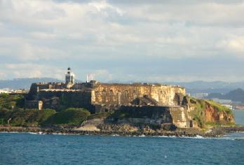
El Morro
Six-level fortress built in the mid 1500's offering spectacular views of San Juan Bay. National historic site. Open 9 - 5pm.
El Yunque Rainforest
The only tropical rainforest in the U.S. National Forest system.
Camuy Caves
The island's oldest natural wonder and site of one of the longest underground river systems in the world.
Tapia Theater
Built in 1832 and one of the oldest theaters in the Western Hemisphere. Still used as an entertainment venue.