Hawaii Earthquake And Volcano Activity
Things you need to know about cruise ship safety before you leave port

Venice
Get to know our slice of Paradise - located on the SW Coast of Fl.
Attractions
Beaches
Canoe/Kayak
Boat Launches
Boat Charters
Fishing Charter
Fishing Piers
Historical Sites
Golf
Parks
Hotels
Relocate
Venice Map
advice > safety > natural hazards -Hawaii
Cruise Ship Natural Hazards
Know before you go!
A natural hazard is a threat of a naturally occurring event that will have a negative effect on people or the environment. Many natural hazards are interrelated, e.g. earthquakes can cause tsunamis.
Tsunami Warning Links
Pacific Tsunami Warning Center West Coast & Alaska Tsunami Warning Center
Caribbean Tsunami Warning Program Puerto Rico Seismic Network
advice > safety > Natural Hazards - Earthquakes Hawaii
Hawaii Seismic Activity
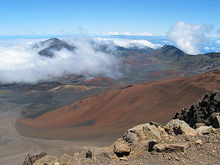
Haleakala (East Maui Volcano) Photo source
The Island of Hawaii experiences thousands of earthquakes each year; most are so small that they can only be detected by instruments, but some are strong enough to be felt, and a few cause minor-to-moderate damage. Most of Hawaii's earthquakes are directly related to volcanic activity and are caused by magma moving beneath the earth's surface.
Earthquakes may occur before or during an eruption, or they may result from the underground movement of magma that comes close to the surface but does not erupt. A few of the island's earthquakes are less directly related to volcanism; these earthquakes originate in zones of structural weakness at the base of the volcanoes or deep within the earth beneath the island.
The Hawaiian Islands are at the southeastern end of a chain of volcanoes that began to form more than 70 million years ago. Many of these volcanoes formed islands that have subsided and eroded beneath sea level, and some of the old volcanoes probably never reached sea level.
 Each Hawaiian island is
made of one or more volcanoes, which first erupted on the sea floor and only
emerged above the ocean's surface after countless eruptions. The islands owe
their existence to a "hot spot" in the Earth's mantle that has changed
location only slightly over the past 70 million years. This hot spot is
located beneath the southeastern part of Hawai`i.
Each Hawaiian island is
made of one or more volcanoes, which first erupted on the sea floor and only
emerged above the ocean's surface after countless eruptions. The islands owe
their existence to a "hot spot" in the Earth's mantle that has changed
location only slightly over the past 70 million years. This hot spot is
located beneath the southeastern part of Hawai`i.
 The largest and most southeastern island of the chain,
Hawai`i, consists of
five volcanoes. Kilauea, Mauna Loa, and Hualalai have erupted in the past
200 years. Lo`ihi, the youngest volcano of the Hawaiian Volcanic Chain, is
still about 1,000 meters beneath the ocean's surface. The name Lo`ihi means
"long" in Hawaiian and was introduced in 1955 to describe the elongate shape
of the seamount.
The largest and most southeastern island of the chain,
Hawai`i, consists of
five volcanoes. Kilauea, Mauna Loa, and Hualalai have erupted in the past
200 years. Lo`ihi, the youngest volcano of the Hawaiian Volcanic Chain, is
still about 1,000 meters beneath the ocean's surface. The name Lo`ihi means
"long" in Hawaiian and was introduced in 1955 to describe the elongate shape
of the seamount.
Island of
 East Maui Volcano,
commonly known as Haleakala, on the island of Maui, is the only other
Hawaiian volcano to have erupted since the late 1700's. Surrounding
and including the crater is Haleakalā National Park, a 30,183-acre
park, of which 24,719 acres are wilderness. Haleakala National Park was established in 1916 as part of Hawaii
National Park - within one week of the creation of the National Park
Service. Haleakala is a 10,023 foot tall volcanic mountain crater, nicknamed
"the Valley Isle" for the narrow plain between Haleakala and the West Maui
mountains. 35 miles of hiking trails allow for exploration of Haleakala
Crater. If weather is favorable during your visit to the summit area of
Haleakala National Park you can see three other Hawaiian islands from the
top of the mountain.
East Maui Volcano,
commonly known as Haleakala, on the island of Maui, is the only other
Hawaiian volcano to have erupted since the late 1700's. Surrounding
and including the crater is Haleakalā National Park, a 30,183-acre
park, of which 24,719 acres are wilderness. Haleakala National Park was established in 1916 as part of Hawaii
National Park - within one week of the creation of the National Park
Service. Haleakala is a 10,023 foot tall volcanic mountain crater, nicknamed
"the Valley Isle" for the narrow plain between Haleakala and the West Maui
mountains. 35 miles of hiking trails allow for exploration of Haleakala
Crater. If weather is favorable during your visit to the summit area of
Haleakala National Park you can see three other Hawaiian islands from the
top of the mountain.
Source: USGS
Good to Know
Hilo is the gateway to the Hawaii Volcanoes National Park, located 45 minutes to the south of Hilo.
Hawaii Volcanoes National Park
The entrance to the park is in the town of Volcano, roughly 40 minutes drive from downtown Hilo. Many people can spend several days exploring all that the park has to offer. There are a number of excellent hikes, showcasing most of the flavors of Hawaiian geological activity. Of course, the thing that most people come to see is the active flow zone of Kilauea. Entrance fees are consistent with other U.S. National Parks.
Pacific Tsunami Museum
Located in Hilo, the museum provides interactive exhibits, documentaries, and docents to explain the tsunami phenomenon and how it affects us in Hawaii, and particularly in Hilo which is dubbed the "Tsunami Capital." www.tsunami.org
About Earthquakes
An earthquake (also known as a tremor or temblor) is the result of a sudden release of energy in the Earth's crust that creates seismic waves. Earthquakes are recorded with a seismometer, also known as a seismograph. The moment magnitude (or the related and mostly obsolete Richter magnitude) of an earthquake is conventionally reported, with magnitude 3 or lower earthquakes being mostly imperceptible and magnitude 7 causing serious damage over large areas. Ordinarily, subduction earthquakes under magnitude 7.5 on the Richter scale do not cause tsunamis, although some instances of this have been recorded. Most destructive tsunamis are caused by earthquakes of magnitude 7.5 or more.
About Tsunamis
Anything that rapidly displaces a large volume of water can cause a tsunami. Typically, tsunamis are caused by underwater earthquakes, but landslides, volcanic eruptions, calving icebergs, and (very rarely) meteorite impacts can also generate tsunamis. These types of events can cause large disturbances in the surface of the ocean, and when gravity pulls the water back down, the tsunami is born. The original Japanese term literally translates as "harbor wave."
International Tsunami Information Center (ITIC) - ITIC coordinates the efforts to extend the services of the national tsunami warning system of the United States to the international community in the Pacific basin.
More About Hawaii Volcanoes
Hawaii Volcano Observatory (HVO)
Tsunami Information
Pacific Tsunami Warning Center (NOAA)
Coastal Seismic Areas
Alaska
Caribbean
Indonesia
Italy
Japan
Volcano Maps
Related Links:
Weather Updates
Travel Warnings
Safety Overview
Cruise Ship Fires
Sunken Passenger Ships
Sudden Lists/Rogue Waves
Unclassified Incidents
Coronavirus
Norovirus
Incidents 2012
Incidents 2013
Incidents 2014
Incidents 2015
More about earthquakes: USGS